
With Google search reaching the 20-year milestone last year, Women Love Tech is now celebrating Google Maps and its 15 years of existence by rewinding back in time and take a look at its extraordinary journey and how it continues to evolve with brand new features.
Let’s be completely honest, what would we have done without Google Maps? How many times would we have found ourselves lost in the middle of nowhere? Countless is the answer.
It’s hard to think of a time before Google Maps, because it’s been so crucial to our daily travel for the past 15 years.
2005 Google Maps Is First Released
The goal of this web mapping service was very simple. Get people from A to B as quickly and as easily as possible.
It was only until 2007 that Google Maps Mobile 2.0 was released along with the Beta for the “My Location” feature where users could be pinpointed on the map via the assisted GPS location which triangulates the cell site and the property location to let users know where they are.

The following year, Google announced that a Google Maps app would be available to use for android operating systems. In that same year, the first commercial Android device, the HTC Dream, was released.
2012 Google Maps Is Downloaded 10 Million Times
A few years later, Google Maps became available to iOS users when it was released on the App Store in 2012, which in only two days had been downloaded a massive 10 million times.
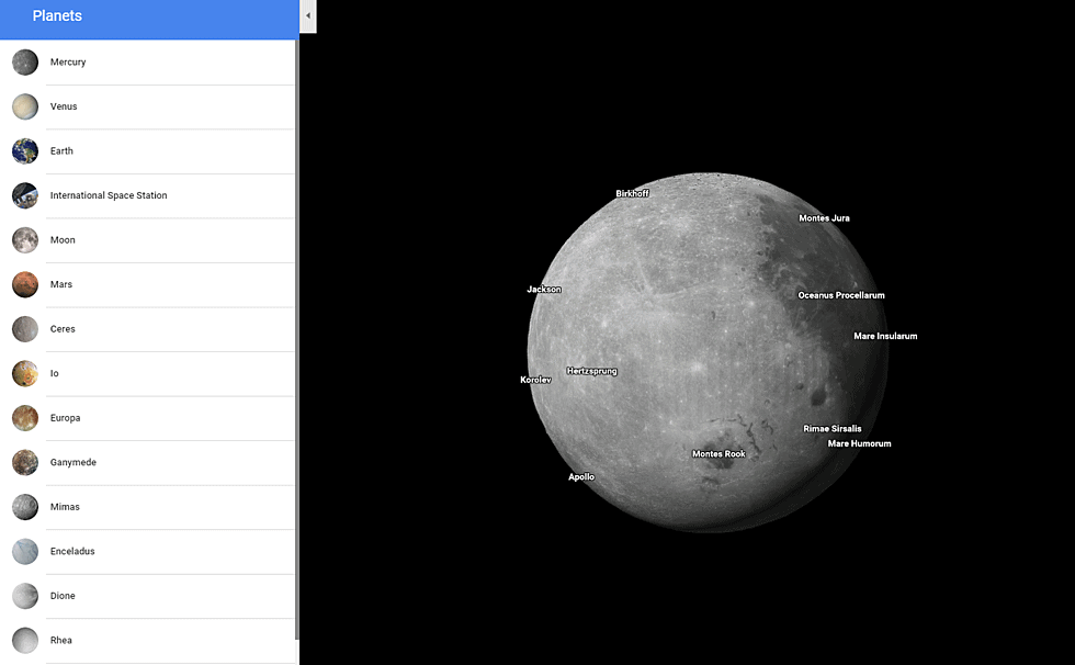
Over the years, Google continuously updated its software, adding new countries, new features, and new interface changes to make the user experience as accurate, easy and pleasant as possible. In fact, in 2017, Google Maps made it possible for users to access imagery of planets and moons including Titan, Mercury, and Venus as well as the Moon and Mars.
What Can You Expect From Google Maps Now
Today, Google Maps serves a much larger purpose than just getting us from one point to the next. To celebrate 15 years, Google Maps has a new look packed with new features!
Get everything you need in the palm of your hands with five new tabs:
- Explore
- Commute
- Saved
- Contribute
- Updates
Explore
Want to go to a nice restaurant tonight? Find out more info on restaurants around your area including those with the best ratings and reviews. You can do this with over 200 million places around the world.
Commute
Late for work? The Commute tab is there to make sure you take the quickest route with the addition of real-time traffic updates, travel times, and suggested alternative routes to take. Whether you’re in the car or public transport, Google Maps has got you covered.
Saved
Users can save their favourite places in the Saved tab so that they can easily access them. Organise future trips, quickly find directions to those places and share them with your friends.
Contribute
In this tab, users of Google Maps can contribute to the community by sharing local information such as details about specific destinations, reviews, photos of the places and more.
Updates
This tab is really interesting and is great for when you want to try the new, trendy places in town as recommended by local experts and publishers. With Updates, you can also privately chat with businesses if you have any queries.
New changes have also included the new icon (above) which is said to “reflect the evolution we’ve made mapping the world.”
What Is Google Maps’ Crowdedness?
Last year, Google Maps introduced Crowdedness to help users determine how crowded their bus or train was, and this year they’ve expanded on that to make your travel experience more enjoyable by using past riders’ insights.
Temperature
Check if your public transport ride is on the cooler or warmer side.
Accessibility
If you have a disability or require additional assistance, you can determine which public transport will have that extra support for you including “staffed assistance, accessible entrance and seating, accessible stop-button or hi-visible LED.”
Women’s Sections
In regions where transit systems have designated sections for women, users will be notified of which ones provide that and if people generally abide by it or not.
Security Onboard
Assure your security by knowing which public transport has security monitoring –whether that be having “a security guard present, installed security cameras or an available helpline.”
Number of Carriages Available
A feature only available in Japan at the moment, users can choose a route based on the number of carriages to increase their chances of getting a seat.
Pick and choose which attributes you want for your trip and get going.
Get a sense of direction
Last year, Google Maps also introduced Live View to help users determine which way they should start walking when they start a route. In the coming months, Google Maps will be expanding on Live View using augmented reality to provide assistance when looking for a place and quickly see how far away and in which direction a place is.
How important has Google Maps been for you? Let us know in the comments section below.


")

")
")


